Pages

Drop Down MenusCSS Drop Down MenuPure CSS Dropdown Menu

Krispy Kreme Cruller

Last night I had a video chat with Mom, Dad and Nanny. They were eating breakfast at Nanny's house- a scrumptious looking breakfast of pork sausage with cream cheese wrapped in Pillsbury pastry dough. Needless to say I was envious of their indulgent meal. So now for some food payback!
Ready?
There is a Krispy Kreme Dougnuts in Mirdif City Center- and guess what they have?

Yes. That's right. GLAZED CRULLERS!!!


NOM NOM NOM!!!


Big Waves, Big Fun

Last night we had powerful winds here in Dibba, which made the sea extremely rough. Late in the night and this morning, the waves were around two meters- a rare wave height here. We spent the morning daydreaming of surfboards. Jen and Matt took advantage of the waves and took out the company body boards and went out at lunch. By afternoon, the surf had calmed down a bit - was between two and five feet. We decided it was a good afternoon to do some rough water kayak training. Griz, Meg, David,  and Nick came out to do some training, and Matt and Matty came out to have fun. I prepped Griz, Meg, David and Nick for their launch- describing what they would encounter paddling into such large waves, and how to paddle through them. Griz and I were side by side blasting through the waves. Each wave we encountered threatened to flip us over, and pushed us towards the shore. It really takes perseverance and power to muscle through big breaking waves. At one point we faced a monster wave, our only option was to dig in and shove ourselves into it. We blasted over the crest and caught huge air on the backside.

Paddling out was exciting and challenging. Everyone was laughing and smiling when we regrouped beyond the surf zone. Then it was time for some work. The team got some practice doing capsizes and rescues in the big seas- which really wasn't so bad thanks to the rolling swell. Nick let go of his kayak and got to experience the difficulty of swimming to a kayak that was floating away from him. It is definitely hard work, and nearly impossible to do in high winds. 
Nick! Your kayak is getting away!
Nick sprinting to get back to his kayak
We all took turns towing each other. I wanted them to feel what it was like to tow someone in large swell- the line jerks as the kayaks go over waves at different times- which is very unpleasant for the tower. We talked some about strategies for reducing risks while towing. I had hoped to do a few more advanced towing procedures but the waves were a bit high and the surf zone was too wide. Hopefully we'll have a few more days of choppy seas in the next month to do more training. 

Matt headed for ta wipeout
After their practical skills, it was time to practice landing. Landing in large surf is difficult and can be most dangerous part of sea kayaking. We discussed how the kayaks would react to the speed and angle of waves. It is very typical to experience your kayak turning sideways and then dumping you when surfing in. The more dangerous possibility is that your kayak will nose dive and go "end over end" launching you like a catapult toward land. After listening to these horrors, there were worried looks on a few faces. Just then Matt showed up in the short surfing kayak to show us how it was done, turning sideways and wiping out right at the end. He popped out of the foam smiling. Emboldened by Matt, they charged forward. Griz and Nick were the first to go- both of them got flipped by big crashing waves. Then it was time for me, and Meg and David in their tandem, to land. We all, of course, wiped out but had tons of fun charging down the face of the wave. 

Grizz catching an epic wave
 The thrill of catching a wave is worth the bumps and bruises from the wipeout. Our training session turned into a massive surfing session- we paddled out over and over to catch more waves. We all cheered when someone caught a massive wave and wiped out. We even drew a crowd- a bunch of locals and western expats were camping on the beach, and came to watch us surf. I even managed to catch a wave backwards in the little surf boat, and rode it backwards all the way to the sand.

PADDLE!!!!!!

Success!


Hidden Oasis Trek in Ras al Khaimah


A few days ago, all the staff from Absolute Adventure headed out to Ras al Khaimah with Ram to learn a trek that until now, only Ram knew. We drove to a wadi in Ras al Khaimah where there is lots of new construction. I have to say I was sad to see the new construction on the road. I went climbing in this wadi last year, and much of the really amazing rock climbing has either been blown up to make way for the road, covered by the earth used to build the road, or is completely unaccessible.  Some of the climbing still remains, though it is harder to get to. Thankfully, the wadis we trek through are so remote, they remain completely untouched by the new construction.

If you would like to go on this trek, you can head out with Absolute Adventure

The trek began with a pump up a steep rock ledge that ran along the wadi rim. We looked down as we hiked to see water flowing between the boulders in the wadi below us. The ledge slowly levels out and continues horizontally for a while before descending back toward earth, where it meets up with the top of the drainage that was once below us. 


Walking along the edge
We stepped off the ledge onto flat ground, surrounded by the ruins of a very small village. After passing through the village, we arrived a a large drainage filled with huge boulders.


The massive boulder field
Weaving around boulders, we found and followed an ancient path, small stone stairways hidden among the enormous rocks. We had fun jumping from rock to rock and finding different vantage points from atop the house-sized rocks. 
Tony climbing old steps up a massive boulder
Summiting the drainage rewarded us with a sudden view of green; an oasis of palm trees, tucked between the cliffs. 


The oasis high in the mountains
Beyond the oasis we entered another dramatic canyon with vertical walls. It rained recently, so there were dark streaks where little remnants of streams flowed down the rock walls. 


A dramatic canyon


Deeper into the canyon, we scampered up rocky staircases and ladders formed by dry waterfalls. 
Walking up dry waterfalls
Climbing up waterfalls
Stepping out of the canyon, we walked on steeply sloped mountainsides, headed to the highest point of our trek. At the summit of the mountain, we could see all the way to the sea. 

It was at the top of this mountain where we came to Musaibat village. Musaibat village is a small, and extremely remote village surrounded by towering peaks. There are several Pakinstani men who live in the village and care for the goats that belong to the families who own the village. These men live in extremely rustic houses without running water or electricity. They were very welcoming to us- it seemed they were excited to have company. Ram, who is from Nepal, speaks fluent Hindi and Urdu in addition to his own language, which made it easy for us to communicate with the goat herders. They invited all fifteen of us in for tea, which they made by boiling water over an outdoor fire. 


The two goat herders boiling water over a fire
An inside view of the small house

Waiting for tea
Ram pours us tea
The tea they make is very sweet. I think they make it with Lipton Yellow Label, goats milk and tons of sugar. We were thankful for their generous hospitality, so we compiled a bag of goodies from the contents of our packs to return the favor. 

We thanked them warmly and headed out. As we began our descent, I looked up to see one of the men taking our photo with his cell phone. We all got a kick out of it, smiling and waving for the camera. I was happy that they were as curious about us as we were about them. 


The trail along the mountainside soon transformed into another lofty stone ledge that hugged the side of the mountain. 
That's me pausing along the ledge for a photo
Goofing off on the ledge
Our views change as the ledge snakes around the mountainsides- we see the valley below, sheer rock faces around us, and the sea in the distance- a brilliant magenta mirror reflecting the setting sun.

Traversing the mountainsides, look how tiny we are compared to the mountain

The ledge fades into the side of the mountain, becoming a rough, rocky trail. As we descended down a slope we passed a tiny but lush date farm surrounded by a high metal fence. We stopped to rest next to a remarkable sight- two small rock pools filled with freshwater, ferns and mosses thriving around them. Ram explained that this is a natural spring that flows all year. The locals have built these small rock walls to form pools to collect the water. 
The tiny date farm on the slope
One of the pools, magical in the setting sunlight
We reached another drainage filled with boulders, and began rock hopping in the twilight. By the time we got back to the cars, night had begun. 

Three Epic Days: Day 2; The Day of No Photos

I apologize in advance for the lack of photos from this day. We were all pretty miserable. I was unwilling to loose dozens of yards I had gained in a headwind to stop to take a photo.
I listened to my marine radio before heading to bed around midnight the night before. NOAA had changed the forecast for the following day. The winds were now predicted to be 15-20 knots from the North East- our direction of travel. We went to bed late that night knowing the following day would be long and hard. We got up at 6am to get on the water by 7am.
The first mile wasn't so bad- we were still protected by large stands of marsh grass. But as we came around the corner, the North East wind blasted us. Our first target was the now abandoned Carteret Hunting Club on South Core Banks. It's about 5 miles from our starting point at Great Island Bay, and several miles south of New Drum Inlet. I like to stop here with my groups to get out of the kayaks and eat a snack. It's also a good place to hide from storms. We pushed and dragged ourselves against the wind. It typically takes around an hour and 45 minutes to get from Great Island to the hunting lodge. At 9:45 (2 hours and 45 minutes) we still had a little over a mile to go. In the shallow bay on the approach to the lodge, there is pretty good clamming to be done- and we ran into local guys wading in the water clamming. When their buckets would fill up they would empty them on their nearby anchored boat and keep working. Tony paddled over to them to chit chat and let them borrow his knife. He held onto their skiff to keep from loosing precious ground. We weren't even a third of the way into our journey for the day and I was desperately wishing they would offer us a ride to our next stopping point. I was already exhausted. We landed at the hunting lodge around 10:00 and decided to only rest for 15 minutes. When we landed it was apparent that everyone needed a physical and mental break from the headwind. The howling wind combined with the overcast skies and general wetness that comes with sea kayaking was making me cold. I wished my PFD had handwarmer pockets for the first time. I stalked around the hunting lodge trying to find a way inside which would give me relief from the cold wind. As soon as I rounded a corner that was sheltered from the wind, swarms of mosquitoes assailed me. I sprinted back to the shore where our kayaks were beached to try to get away from them, even running into the water. Now I had brought the mosquitoes over to torment everyone else. They guys decided to rest longer here, hoping that more rest would give us the fuel we needed to get to our next stopping point. We decided to leave at 10:45. For me, the minutes dragged by because I was so cold. I hated standing around and shivering so I scrunched down in my kayak - I can nearly lay down inside it- using the boat to shelter my unprotected legs from the wind. My ears and mind on the other hand were unable to find refuge from its constant noise. Tony and Drew asked me if I had more clothes. I was only wearing board shorts and a long sleeve quick dry shirt, along with my PFD. I did have more clothes- I had one pair of long pants and a lightweight fleece pullover. Tony suggested I put them on. I refused. First, I was warm when we paddled, but cold when we stopped. If I put them on and paddled, I would be too warm. Second, if I wore them while paddling, they would get wet and when we arrived at our final destination I would have no dry clothes to wear. I decided instead to endure being cold knowing I would have warm dry clothes when we stopped. 
Our next stopping point is a place we call Bird Crap Island- its in the middle of Core Sound, due east of Atlantic. It is about 6 miles or so from the hunting lodge. Once you get there, it's another 7 miles or so to Long Point Camp- our final destination for the day. When you sit in a kayak at the hunting lodge, you can't see Bird Crap Island - you've got to get up on the dock to be high enough to see Bird Crap on the horizon. We walked down to the end of the dock to show Dave, Mike and Phil where we were headed before shoving off. 
We set off, grinding and pulling ourselves against the constant 15 knot headwind, pushing harder when it gusted to 20. I was relieved to not be cold anymore but I'd traded warmth for exhaustion. We pushed and pushed. We paddled between marsh islands- relishing in the tiny reduction in wind they provided, before hitting the open sound where we could see Bird Crap. Out on the open sound the waves picked up and the wind was worse. Our little group stayed close together in case someone flipped or needed a tow. In some areas of the sound there are nets strung up across the water, held up by large posts driven deep into the sand. We clung to the posts to take a rest from paddling and relieve ourselves from the solitude of paddling in high winds. Even when you're several yards away from someone, conversation is impossible. It's a mental relief to have a conversation. Eventually we left the posts because we were spending too much energy hanging on and staying upright as our kayaks violently bobbed around in the waves. We each found a pace and maintained it almost mechanically. Resting for even a stroke or two meant a loss of not only momentum but several yards of distance we had fought hard for. As we pushed North, we noticed a Coast Guard helicopter flying South over Core Banks. They flew low, like they were looking for something, but weren't circling. I assumed they were on the lookout for boats and swimmers in need of assistance because of the unexpected turn in the weather. I don't know for sure, but I would think that they would monitor risky areas when things start to get crazy, even if no one is yelling "mayday" on channel 16 yet. By 12:30, officially afternoon, we were still 3 miles or so from Bird Crap Island. I yelled over the wind to Tony that I thought we weren't going to make it. His response was that we still had 8 hours of light left and we could make it to Long Point. Even if we didn't make it all the way to Long Point, there were other places along the mainland we could stop for the night, so we kept paddling. The Coast Guard flew over Core Banks again, this time headed North. They must have been doing patrols. I have to say our little group was pretty self sufficient. Even the National Park Service says that sea kayakers are the least likely to need rescues in their area because they tend to be the most prepared. We go out prepared to support ourselves and rescue ourselves and there have been fewer than a handful of times when we've bitten off more than we could chew.  As a sea kayaking guide, I'm looking out for the sometimes large group of sea kayakers I'm in charge of. I find it extremely comforting to see that Coast Guard chinook fly by and know someone else is looking out for me. So anyway, on with the story. The coast guard flew North as we continued to struggle North East. The large waves with whitecaps we were battling seemed to grow a little bit. It took a little more push to get up and over them. I felt the wall of wind I had been pushing against all day get a little heavier. Not sure if it was exhaustion or an actual change in weather, I motioned for Drew and Tony to meetup with me. We paddled toward each other to get close enough to yell. 
"Is it just me or is it picking up a bit"
"I was thinking that too. It seems like its getting rougher."
"Do you think we can make it to Atlantic?"
"It's 1:30 now. We still have what, 2 or 3 miles to Bird Crap and then further to Morris' Marina. How many hours is that? And there's no real campground there."
Tony and I looked West to see the house with the copper roof- our reference point to get us into Cedar Creek where there was an established campground and knew it was the right call. We were all beyond exhausted and I was cold. We gathered together, told the new guys what we had decided and headed West. It seemed like as soon as we turned the wind picked up. I think it was blowing 20-25 knots with gusts from 25-30. It was some of the worst wind I've ever paddled in. The waves were over our shoulders and crashing over the decks of our kayaks. Because the waves were now at our beam (next to us) we had to be extremely cautious to keep from flipping over. Sometimes a wave was so big I would pull myself up onto it and then hold my paddle out of the water to keep my balance. Our nylon spray skirts weren't enough to keep the all the water out. We were each paddling with 3+ inches of water in our boats. Our decision was bolstered by a third Coast Guard fly by- and this time their flight path changed and they ventured out over the sound and closer to us. Sitting in our kayaks we figured they were signaling to us that we needed to get off the water, and sizing us up in case we needed a rescue.  I'm sure those guys (and girls) in that chopper thought we were crazy. There were no other boats anywhere to be seen. By 3pm we were finally entering the calm waters of Cedar Creek. The water was glassy smooth and I was relieved to not have the wind howling in my ears. Phil on the other hand, was not relieved. He sat in his kayak yelling and cursing "God f***ing dammit I'm so f***ing wet! I've never been this f***ing wet in my LIFE! I HATE BEING WET. F**K this S**T!!!" We couldn't help but laugh. We all deal with the misery in a different way- and it was so funny to hear him- a sea kayaking guide of all things- complain at volume about being wet. And after the danger and misery was over! We finally landed at 3:30 and much to my relief the sun came out. I changed out of my wet clothes, strung up a clothes line, and lay in the sun to bake. When we looked out to the sound, there were giant whitecaps everywhere. It was definitely blowing 25-30 and I was happy we'd made the call we did. 
We paddled from 7am to 3:30pm- a total of 8 1/2 hours. A typical relaxed pace is about 3 miles/hour. So in that amount of time we would normally be able to travel 25+ miles. How far did we actually go that day? 8 miles. A measly 8 miles in 8.5 hours. 
So we had a miserable day- many people ask now why we did it. Why would we put our guides through such torture? For one, we wanted the mileage. The more miles we got per day, the faster we could get through the trip. But that wasn't the only benefit of paddling in such crazy conditions. All the new guides were fantastic. Their mental and emotional states were pretty stable at the end of the day. Such a day is miserable for a guide and impossible for a participant. On days when it gets a little rough (15-20 knots), our guides will be comfortable while our participants endure the same misery our guides endured on the guide trek. This is so crucial- our guides need to understand what participants are going through- and to get that from a guide often takes a higher level of wind and wave height to achieve. Often guides will call base camp (read: me) for assistance in making weather based decisions. They call me for advice- even though I'm not there on the water looking at the conditions. Sometimes we have guides call off a day of paddling when they should have gone out. I knew that when Phil, Drew or Dave called me to say it was blowing like crazy and they couldn't take participants out they actually knew what "blowing like crazy" was. 

Three Epic Days: Day One, June 4, 2012

This summer at Pamlico Sea Base we've got an awesome crew of guides.  A few weeks ago we set off on our staff sea kayaking trip. Every year we take our new guides out on a sea kayaking trek along our usual route. The goal is to show them around so they won't get lost getting from place to place, teach them how to manage a group of kayakers, become a pro at beach camping and get the hang of predicting the weather. Our summer trips usually start in the south- at Harker's Island, head south to Cape Lookout or Shackleford Banks, and then turn to head North along Core Banks toward Cedar Island. Most weeks, if luck holds, the summer wind is South-West- at our backs pushing us North East along Core sound and island chain of Core Banks.
Unfortunately for us, the winds hadn't shifted yet when we left for our training trek. NOAA was calling for South winds on Monday followed by gentle North-East winds the rest of the week. The gentle headwind we scoffed at turned into a full blown Nor-Easter.
Sunday we spent prepping for our trip- packing gear, going over the route, showing the guides how to load a kayak trailer and trying to get a good night of sleep before our trek. Monday morning we had strong south winds- 18 knots in the morning- so we stalled and got on the water a little late because the forecast said the wind would die down a bit in the afternoon. The plan was to visit Shackleford where the wild ponies live and then paddle on to camp at Cape Lookout. The wind was south around 12 knots- enough of a headwind to be annoying and choppy but we managed to make decent time to Shackleford. After pausing near the picnic shelter, we headed on to charge Barden Inlet and head to Cape Lookout. We anticipated the crossing would take longer than usual because both the wind and tide were against us- a scenario we like to call "kayak treadmill."

We ended up making great time to Cape Lookout- landing less than an hour after leaving Shackleford. It was still early afternoon when we finished eating lunch and we were still eager to put more miles behind our blades. 5 miles to our north sat a pavillion where we have stopped many times with our groups. With the stiff tail wind we had, we could probably be there in a little over an hour. Ominous clouds to our North made us hesitant to leave until we checked the radar. There were two storms to our North- both moving East one next to another. The one we could currently see had some high winds and rain, and possibly a little thunder and lightning- it was green, yellow and orange on my radar and sitting right over our destination. I could tell the following storm, which we couldn't see by eye yet, was much weaker. The gap between the storms was at least a couple of miles- enough distance to embolden us to "thread the needle"- a phrase we use when we try to time our departure and speed to squeeze through between storms and make it to land before the next storm hit.

We made great time, but the storm we were trying to beat made better. We were right beneath it when it blew through. The wind at the edges of storms are very strong- we had to paddle hard to break through the sudden head wind and into the wall of light rain. If we rested too long, or paddled too slowly, we ended up back in the invisible zone of wind.


Tony approaching the edge of the storm- the "high wind zone"


Drew pushing to calmer seas beyond the back edge of the storm.


We paused as the storm passed on a marshy island to check the radar and our location. Drew climbed up on a duck blind to look for the pavilion. The only rooftop we could see didn't look right. When I looked at it through the binoculars, it looked mostly like a rooftop but it was partially covered in green grasses. I wasn't sure I was actually seeing a rooftop. We wasted lots of time paddling around looking for the entrance to the cove.


We grew frustrated in our inability to spot the rooftop, and started looking at our other options. We had access to a house in Gloucester, directly west across the sound. We could be there in no time- definitely before sunset, but we felt like we were loosing mileage in the long run by paddling across the sound to get there because we would have to paddle all the way in tonight and then back out tomorrow.  We could keep looking for the pavilion, maybe we would find it soon. Or we could press on to Great Island Camp- a place we knew very well.

We decided to take a risk and press on to Great Island Camp- about 8 miles or so further North. We knew that this would mean we would be making landfall in the dark. Because we had noticed it the night before, we knew that the moon would rise early that night- very soon after nightfall- and that the moon would be full. Tony was sure we could find our way with just the moonlight, but I didn't want to be paddling around in the dark unable to find our landing spot. I wanted the park ranger to turn a few lights on for us. The problem was, the ranger station on the island was already closed. I did know that the family-run ferry service that runs from mainland to our destination would probably be have after-hours numbers for the park rangers out there. A couple of years ago that ferry service came to pick me up when I was sick on trek and let me stay in their house until Reggie came to get me, so I felt sure they would answer and help me out. I was right. The mother of the family answered the phone and remembered me. She still had my cell phone number saved in the phone! She called the park ranger and filled him in on our dilemma, gave him my number and called me back to let me know. People in Core Sound take good care of each other. Soon the ranger- Jesse, called me to let me know he would not only leave the lights on for us, but would stay awake and in contact until we landed. 

With the confidence that we would definitely find Great Island Camp, we set out again. The 18 knot tail wind had died with the storm. We enjoyed a relaxing sunset paddle in calm seas. 


The boys paddling behind me: Drew front left, Tony front right, Phil back left, Dave, in the very back, and Mike hiding somewhere.


Paddling at sunset


The fire of sunset dwindled into twilight, when everything turns into shades of purples and blues that get darker and darker until suddenly we looked around to realize it's deep dark night and we couldn't see each other. The clumps of marsh grass on the horizon that were visible at twilight became as black as the horizion they sat against, which was as black as the water we floated on. We pulled our emergency boxes from our cockpits to break out the glowsticks. My headlamp got strapped around my head, but I used it only when I sensed I was about to run into something. Bright lights ruin night vision and the need for us to be seen by motorboats was nonexistent.  I glanced at my deck compass once in a while to make sure my sense of direction was still on point, and we kept paddling. It seemed like just moments after we cracked our glowsticks the moon began to rise over the island. It rose right in front of us, and for the time that it hovered near the horizon I felt like that auspicious and glowing orange moon was my destination. I have launched many times in the darkness before dawn with glowsticks on my kayak pausing in the middle of the sound to paddle directly in the center of the blinding reflection of the sun as it rose. This was the first time I paddled through sunset and on into darkness and the first time I floated squarely in the shining reflection of a Harvest moon.  My attempts at capturing the moment with a camera were fruitless as I would have needed a tripod and a wide angle lens so you'll have to be happy with the description. (I looked it up, sunset was at 8:17 pm, twilight ended at 8:43, moonrise was at 8:44, so literally, right after the sun went down, the moon rose)

We soon discovered that we would have been very blind had the ranger not turned on the lights for us. The features of the islands- the silhouettes of buildings and squat trees are already difficult to identify in daylight, and are completely invisible in the dark. As we paddled and time wore on, the moon rose higher and the glowing windows shifted from being arranged in a cluster to a long string. In reality, the cabins are set in a row, long and narrow, along the length of the island. When you approach from the South West, they appear clumped together at first until you get close enough. Now which light was the ferry landing? We took a guess and started paddling toward one of the buildings only to hit marsh grass and still seem over a mile from the building. We turned away, back out toward the sound and tried to resume our North East bearing. Because we couldn't see ahead of us, we couldn't tell how far out we needed to go to get around the marsh grass. I started to worry that we would end up having to drag our boats through mud and muck to whatever building was closest. I called the ranger to see if he could drive his ATV over to the ferry landing and turn his lights on. He did us one better, he drove to the landing and put his flashing blue lights on. There was no mistaking where the ferry landing was. Much to our surprise, we saw his lights streaking through marsh grass. We were too far south by about 100 yards and there was a giant stand of marsh grass between us and him. We would have to paddle out and around it to get to the landing. Then Tony had an idea. The moon was full- causing a spring tide and very close to the earth- making the  spring tide much higher than normal. To our delight we could paddle through the  marsh grass directly to the blue lights and the landing. 

When we landed we were immediately assaulted by mosquitoes and no-see-ums. Phil was cussing and swatting as the rest of us were dancing and stomping to try to evade them. We all grabbed what we needed as fast as possible and ran. We ducked into the front porch of an empty cabin to escape the bugs. It was 9:30 and we still had to cook dinner. Sitting outside cooking in the swarm would be miserable, and we would probably eat a good number of bugs in the process, so we decided to covert cook dinner on the porch.  We listened to our radio while we cooked. The forecast had changed. There would be strong North East winds in the morning- 15 to 20 knots. Our late night would end in an early morning. We would have to hit the water early to make sure we had enough time to reach our destination before nightfall. After shoveling food into our growling stomachs we hastily set up our tents and fell asleep around midnight. 

We had a very eventful day- a headwind and the tide against us, an encouraging tailwind, exciting but harmless storms, confusion and frustration at our feeling lost, a breathtaking sunset and moon rise, a mad dash to cook dinner accompanied by the ominous forecast for the following day.
 
Lessons learned:
On the pavilion at Codd's Creek: I'm still convinced we weren't far enough north during our search and had we been at the right spot, we would have found it. After our trek we asked a park ranger and he told us that the pavilion was mostly destroyed in the last hurricane and is now very hard to spot from the sound side. If I had downloaded GoogleEarth onto my phone before our trek, I would have easily been able to tell if we were too far south of our destination or not and have a better idea where the entrance to the bay was because google earth puts a pinpoint on the map at your current location. I now have google earth installed on my phone which will probably come in handy some day. 
On paddling into nightfall: Paddling at sunset is pretty gorgeous, as one would expect it to be. Making the decision to paddle into the darkness can be scary- but we made it because we knew the area well, there were no storms on the horizon and we had the park ranger to light our way. Without these assurances we would not have taken the risk. It's easy to start to panic when you think you're paddling to your destination and all of a sudden you run into land and you aren't where you thought you were. I felt a bit of panic myself when we realized we were unable tell the buildings apart by their lit windows. Paddling into the rising harvest moon was the highlight of our trip and really magical. I think it would be a really awesome experience to re-create for adults on treks in the future. 

Review: SealLine Baja Deck bag for expedition sea kayaking

A deck bag is crucial for long days on the water. It provides quick and easy access to things like phones, sunscreen, hats, snacks and Gatorade pouches.
I've used a few different deck bags over the years so my requirements evolved to be very specific.

What to look for in a good deck bag for sea kayaking:

  • Made from durable waterproof material
  • Rigid structure to make it easy for me to dig around in it single handed
  • Fast and easy to open- I don't want a deck bag with a roll top closure that takes forever to open and close
  • Fast to take on and off my boat
  • Low profile to reduce wind resistance
  • Small enough to safely put in my lap under my spray-skirt in high winds without hindering my ability to wet exit
  • Splash proof
  • Dlastic d-rings to attach a strap so I can easily carry the bag on my shoulder. When I get to Ocracoke I use my deck bag like a purse- which gets me lots of strange looks.


So far my all-time favorite deck bag is the Baja Deck Bag from SealLine.


What I Love 
Size & Storage
  • Perfect Size- It is big enough to hold what I need it to, but not so big that wind resistance is a problem. It is small enough to keep in my lap under my spray skirt in extremely high winds. It has a stiff plastic insert that keeps the upper side of the bag in a curve shape which keeps the bag from collapsing and makes it easy to find your stuff. 
  • Zippered Access- There is a zipper to get into the main part of the bag- which in the above photo is covered by a rubber flap to make the zipper more water resistant. There is an outer mesh pouch that I use to keep my chapstick and other random bits in. 

Attachment Points
  • Straps to Rigging- The bag itself attaches to the deck rigging with two tough strips of rubber lined with velcro with two plastic buckles at the end. Un-clip the buckles, pull apart the velcro, and slide the straps under your deck rigging then clip to secure. I find it easy and quick to put on and take off this deck bag. I have used other bags that attach in different ways and this method is my favorite. 
  • Bungee- I use the bungee on top to hold my map and hat sometimes. The clips on the bungee are made to be a fast and easy paddle holder. I've only used them to hold my paddle a couple of times- it worked but I didn't feel like it was that secure. 
  • Carry Strap- The removable strap is the perfect length to throw over my shoulder- making it easy to carry my bag to my tent or around Ocracoke as a handbag.

So far so good. It seems like the perfect bag- and it is. Except for one major flaw. 

     The zipper sliders are metal. Why is that a problem? This is a bag for sea kayaking- in the ocean. When exposed to salt water they corrode. And no longer open or close. So you either end up with a bag that is stuck open or a bag that's stuck closed. Neither is good. 
      These are also our deck bags of choice for our sea kayaking guides at Pamlico Sea Base. We have four of them that our guides use all summer. In order to keep them working, the zippers have to be sprayed with silicone lubricant at the end of every trip. This is obviously annoying. 
      After sitting idle from August to May during our off season, they are stored in a closet in our boat shed. The boat shed is three sided, so although the deck bags don't get rained on, they aren't protected from the humidity in the air. After 9 months sitting idle, none of the zippers work. They are stuck closed. 
So until they fix this massive error, I can't say that the Baja Deck Bag is the perfect deck bag, but it's the best I've used so far. 

Dibba Fish Market

The fish market- on a not-so-busy day
Wander into the mina (port or harbor) in Dibba any afternoon except Friday and your nose will find the fish market for you. The buzz of activity is hidden from the road by big refrigerated trucks waiting to be filled with fish. Weaving through and often squeezing between the trucks you'll come upon an open area with orange tarps laid out to protect freshly caught fish from pavement. There is never enough tarp space, so many fisherman display their catch on their boats.  There are no size limits, catch limits or restricted species here- so you'll see a huge variety of marine life at the fish market. Large sharks are pretty common- along with parrot fish, cuttlefish, squid, black tuna, grouper, red snapper, swordfish and a bunch of others that I don't recognize.

An enormous hammerhead shark. We guessed it was 14 feet long.
The shark next to it was a decent size shark at around 8 feet
It's easy to be intimidated here, especially for Westerners. Everyone is shouting in Arabic, people are walking quickly from seller to seller, fish are being packed into baskets layered with ice and heaved into trucks. There is constant movement and constant noise. Browsing the catch on the tarp means gingerly stepping between carcasses on slippery, blood and water covered tarps. Push your way through crowds to get a look at the catch on the boats. If you can't identify fish species, and more importantly don't know which ones are tasty, don't go without someone who does. The locals don't know the western fish names. It is typically warm and sunny at the fish market- the smell of sweat mingles in the air with the fish smell- and there's fish grime and guts all over the ground. Stray cats hang around trying to steal small fish when no one is looking.  Don't wear nice shoes and expect to leave feeling grimy.

Kent and the snapper
The first time we went, I was determined to buy a fish- we were planning a cookout that night. I found a nice big red snapper I wanted. I just stood there pointing downward and asking every man that passed "how much." Eventually my stubbornness paid off because someone who spoke a little English appeared to bargain with me. He was asking 250 dirhams- around $75- way, way out of our budget. Haggling is customary and expected here. A decent price is usually half of the amount they start at. I wanted to pay 140 dirhams- around $38 for the fish, but I couldn't get him below 180.  My companions and I gave up and walked away. We were checking out some black tuna on one of the boats when someone tapped Kent on the shoulder.
     "It's okay 140," the man says, wobbling his head to the side and waving his hand with a single flick of his wrist.  We headed back over to the snapper.
  After collecting our fish we head to this building where we can pay $3 to have our fish cleaned. The building feels vastly empty, clean and quiet compared to the fish market.

The guys who clean the fish don't speak English, so I motion as if I am holding a knife and cutting a fillet off the fish and the guy gets the idea.


A smaller snapper -photo credit Jessa Hobson
He scrapes the scales off with a short board with nails sticking out of it before pulling the guts out. Tony and Kent left me to supervise the cleaning process while they went back to buy a tuna. The fish cleaner slid his knife into the fish flesh by the gills to slice the fillet off. The fillet was nearly three inches thick and at least a foot long. I tried desperately to call Tony to tell him not to buy a tuna. Oman mobile cell phone signal isn't the most reliable. Not knowing if he could hear me or not, I tried to tell them that the snapper fillets were huge and not to buy a tuna. Much to my amazement Tony and Kent returned without a tuna. Apparently the only word Tony could make out was "huge" so they assumed I was trying to tell them that the fillets were enough to feed everyone.
This first successful trip to the fish market let to many more. We learned to walk away from a fish we really wanted only to be tapped on the shoulder as we stood browsing by the competitor's boat. We also learned just how much we could get away with paying for these fish. I got the snapper pictured below for 50 dirhams - just over $10. We originally agreed on 40 dirhams but when I pulled out a 50 and expecting to get change, the price jumped to 50 dirhams. Next time we'll bring exact change.

Curtis and Kent's Perfectly Easy Red Snapper
Ingredients:
-red snapper fillets with skin still on (the skin adds flavor and is good for you)
-sliced lemon
-garlic
-butter
-salt
-pepper
-basil
-aluminum foil

Directions
Place fish fillets on flat pieces of foil, skin down. Chop fresh garlic cloves into relatively small chunks and place around fish. Sprinkle salt, pepper and basil onto the flesh of the fish. Place several chunks of butter on top of the flesh. Then lemon slices on top. Fold, roll and pinch the foil to make airtight pouches. 
Place pouches on grill with medium-high heat until fish flakes easily with a fork. Serve with tasty alcoholic  beverage.

Dad's gonna be jealous....

It looks like my Dad is going to have to fly half way around the world to get his fix of Krispy Kreme.
That's right. Krispy Kreme, the doughnut company (founded in my dad's home town might I add) has stopped making the Kruller. Stopped making the Kruller, except in Dubai apparently.

I took a photo to prove it.


Mike came to visit us in Dibba last night. We were at the beach when he arrived at our house. We got a call from one of our housemates.

Kent: "Mike brought us presents, they're on the kitchen table."
Curtis: "What, booze?"
Kent: "Better. Krispy Kreme."

So Dad, I couldn't exactly bring it home for you. It would definitely get stale and possibly moldy during the 8 days until I leave, and then the 10 days in France. So I did the next best thing. I ate it and took photos!


Sharjah Souqs

On a day off in February, we decided to see the souqs of Sharjah. In UAE and Oman, souqs are shops that sell traditional and modern items. The souqs are often organized by type- textiles, produce, spices, etc. Haggling is expected and respectful. Only fools (and tourists) pay full price.

During our drive, we saw a man riding a camel across a busy highway. I’m sure drivers around us were annoyed as we slowed to take photos.


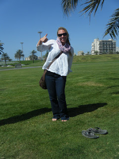
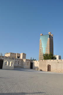
Sharjah is an extremely confusing city to get around. The signs tell you what neighborhood a street heads toward instead of what major highway or direction they go- this is really frustrating for anyone who doesn’t have the layout of Sharjah neighborhoods memorized. Luckily we had a Time Out Dubai book with a basic map of Sharjah- enough to get us to the right neighborhood. We arrived at mid-day- not the best time for shopping because many shops are closed- but a great time to find free parking. We parked in a free spot right next to the Central Souq where Jessa was excited to take her shoes off in real grass.

The Central Souq


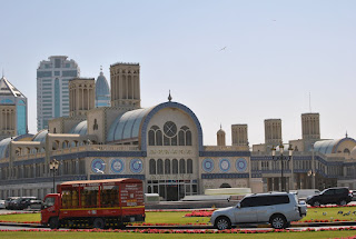
The central souq is two large, two story buildings, connected by hallways that pass over a road. The second floor is full of more traditional wares- jewelry, silver, old cultural relics, pashmina shawls, and carpets. Most of the shops on the bottom floor sell modern clothes, shoes, and jewelry. The more traditional souqs are captivating- each in their own way.
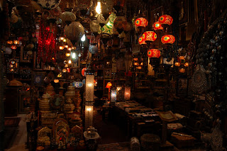
Some shops are a feast for the eyes- with glowing glass lamps in hundreds of colors.
This souq is packed to the brim with housewares, illuminated by the lamps and lanterns within. We all love to daydream about owning one of the big chandeliers.

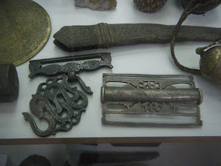
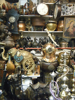
Souqs with ancient artifacts transport you to other places and times - times of adventure and intrigue- when the far reaches of the world were still mysterious and the wonders of the world not yet understood. Some of the items here are thousands of years old- or so the shop keeper claims. In this case are coins from 195 BC, ancient Egyptian gold jewelry and Arabian knives. I held a pair of gold and jade earrings supposedly from Ancient Egypt. I wonder if looters stole them from a tomb furnished for the inhabitant’s afterlife.

A display case filled with old knives, coins and jewelry.


Old belt buckles


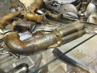
A beautiful revolver covered in Arabic script. I think this would have been my gun if I was a pirate.


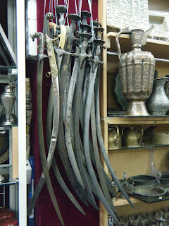
And one of these my sword...


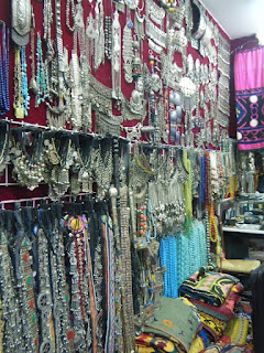
Afghani jewelry on display


One souq we really enjoyed was one full of more modern exotic items. The wares here were just as exotic and traditional, but not ancient and therefore less expensive. Tony found Tibetan prayer bowls he liked. I found brass spyglasses, ship’s helms, heirloom brass compasses and this throttle for a steam boat- just like the throttle on first ferries that ran to Ocracoke from the mainland. It would be awesome to have a throttle like this one at Pamlico Sea Base, or even one of the ships' helms so I asked for prices.


The shop keeper was asking 25,000 dirhams - around $6,800, for the throttle. The helms (ship’s wheel) were going for 600 to 900 dirhams. I could probably talk him down to 400 ($108) or so, but getting it home would be a challenge.
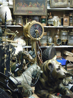
Coffee pots, a diving suit helmet, statues from the far East and traditional hookahs.


Enchanted by the relics within, we left the central souq scheming buy things when we returned.
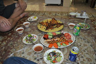
Hungry, we wandered the streets until we found a Lebanese restaurant where you eat in the traditional way- seated on a carpet floor sharing a communal meal. We bought a variety of dishes and shared.


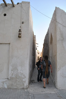
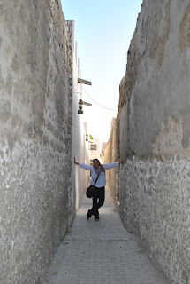
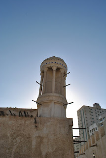
We hit the streets again to find Old Sharjah- where remnants of the old city remain. The buildings here are low and made from the resources available to those early inhabitants. We walked the narrow passageways and wondered at the construction of the buildings.
Tony and me walking down a lane


Jessa


Old and New Sharjah


A beautiful doorway


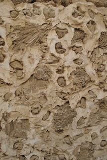
The buildings were constructed by stacking chunks of coral like bricks


There are souqs in Old Sharjah- but unfortunately they are only open in the mornings so we missed out on this trip. We looked into the windows of the souqs to see a trove of awesomely cool stuff -like carved ibex horns, giant platters carved with Arabic script, leopard skins and traditional furniture- so we’re planning to go back sometime to check them out.
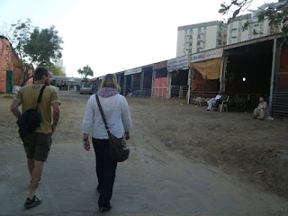
Our last stop was the animal souq. We parked nearby and followed our noses to the shops. The smell of livestock and hay is detectable from several blocks away and is very conspicuous in the middle of a big developed city.


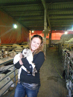
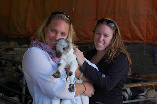
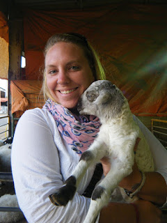
The sellers were excited to see westerners in their market and were eager to let Jessa and me hold baby goats and lambs.


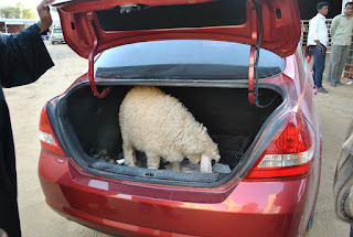
One local guy bought a sheep. We were shocked and amused when he pulled his car up and the sheep was loaded into the trunk.


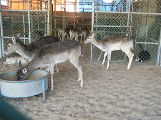
Deer were for sale too, although I can’t imagine what purpose they serve.


We strolled by the stalls selling cattle and horses, and then noticed a small goat was out of it’s pen. Jessa and I were inside the stall with the loose goat, Tony and Stephen were outside the stalls walking in the dirt driving lane. We tried to get the attention of the shopkeepers to alert them to the goat. They were preoccupied, and we quickly learned why. As we tried to get their attention, two men came bolting out of the neighboring stall, running full speed and looking over their shoulders. A bull had gotten loose, and he was angry. He chased the men, swinging his horns to and fro at them. One man made a futile attempt to stop it by stepping on the lead rope that dragged behind it. Tony jumped behind a tall metal gate and Stephen behind a car. I watched the bull exit the neighboring stall. I was in the neighboring stall, surrounded by walls and filled with pens of sheep. With nowhere to go, I hoped the bull wouldn’t turn and stood still to not attract attention. My efforts were not rewarded, he turned and ran into my stall. I knew he wouldn’t bother trying to knock a fence down, so I jumped in with the sheep and stood still. What I didn’t know was that Jessa was also in the same stall with me, standing behind me. She didn’t notice his direction change until he was running right toward her. As Tony and Stephen looked on, she frantically looked around for somewhere to go. Seeing me standing with the sheep, she leapt like a deer over the fence and quickly turned back toward the bull, shielding herself with her arms, holding the fence and nearly knocking me over in the process. The bull stayed his course and ran right to the back of the stall down a narrow lane. Unable to turn and unwilling to walk backward, he was stuck. The shopkeepers, Tony and Stephen came out from behind their hiding places and stood at the sheep pen. The Pakistani and Bengali keepers were bent over with laughter. Once they had contained themselves, Tony asked them how much for the two American sheep which set them off laughing again. Jessa and I climbed out of the sheep pen and we headed to the indoor animal souq where all the pets are sold.

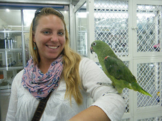
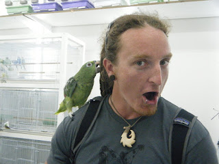
We were hit by a wall of stench as we stepped inside. Each vendor has a variety of pets- you’ll often find cats, dogs, fish, parrots, rabbits and mice all in one shop. A few years ago you could find really exotic pets like tigers and leopards here but laws have changed in the past few years and you’ll rarely find such animals in plain sight. The shop keepers here are very willing to put birds on your shoulders and puppies in your arms. Tony and Jessa made friends with a parrot.


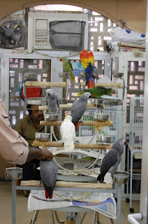
Falcons are one of the best selling birds here because of the long standing hunting tradition. Many Emirati men own falcons and train them to hunt. Unlike in the States, here you don’t need to be a licensed falconer to own one.


Now that we knew had the Sharjah souqs figured out, we vowed to bring the rest of the gang to check them out one day.