Pages

▼
Drop Down MenusCSS Drop Down MenuPure CSS Dropdown Menu

Pimp your PFD -What a kayaking guide puts in her PFD- a video update for 2025

Way back in 2010, I wrote this post on what I kept in my Stohlquist kitty PFD while leading sea kayaking expeditions. When I wrote that post, I had led around a thousand miles of trips. Now that mileage has grown significantly, and what I carry in my new Kokatat Hustle PFD has changed a little bit too. Here is a video update, and more info below the video if you would like to read more. 


Here is what is in my Kokatat Hustle PFD in the video:

Fox40 Micro Whistle - little and LOUD

NRS Co-Pilot Rescue Knife - the blunt-tipped knife with a quick release sheath designed to integrate into a PFD knife holder

Petzl E+Lite Ultra Compact Headlamp - the tiny waterproof headlamp that lives in my PFD so I always have a light

Black Diamond Storm 500 Lumen Headlamp - I carry this when I plan to be out in the dark. It is VERY bright

Petzl Djinn Bent Gate Carabiner - Totally rust-proof. The bent gate makes it smoother to use. 

My favorite reef-safe sunscreens:

Sky & Sol Mineral Tallow Sunscreen - the best sunscreen for your skin

Badger Mineral Sunscreen - clean ingredients, super effective sunscreen 

Blue Lizard Face Stick -this fits REALLY well in a PFD pocket

Badger SPF Lip Balm - clean ingredients

But what about your phone?

Because I paddle in salt water, I keep my phone in the Nite Ize Runoff Phone Case that allows me to still use it while keeping it safe. Unfortunately, in the bag it doesn't fit in my PFD, so I wear it around my neck, and tuck my phone between my body and my PFD 


What I'm adding in 2025


I've always kept my water bottle in my cockpit, which is awful when I'm in choppy conditions and wearing a spray skirt. Leaving my water on the deck of my boat means that it gets really hot in the sun. I've always hesitated to put a hydration bladder on my PFD, but this year I'll be leading 6 weeks of trips and I have decided to try it out. 

NRS makes the Swig PFD Hydration pack, which fits most of their PFDs, but I am unsure whether it will fit mine. I plan to order it and see if it fits. If it doesn't I guess I'll be making something myself. 

Blissful Beach Camping

how to beach camp
Beach camping in Hong Kong
Beach camping is one of those outdoorsy things that sounds like a great idea. Spend your day fishing, swimming, and soaking up the sun then drift off to sleep to the sound of the crashing waves after a glorious sunset.

Our imaginations tend to gloss over the not-so-nice realities of our daydreams. Just like dreaming of moving to Paris means you'll have to learn French and pay 5 euros for a coffee, camping at the beach comes with a few challenges that can make for a miserable time. Has one of your beach camping trips ended in disaster or misery?
Things that (usually) Suck about Beach Camping
  • Sand gets EVERYWHERE, in EVERYTHING
    The worst line in any Star Wars movie? I think so.
  • It's hot
  • Sunscreen is sticky and gross
  • There are bugs that bite
  • Your tent blows away in the wind, or leaks when it rains
So while I can't magically make any of those things go away for you, I can share the tricks I've learned that make camping on a beach actually really wonderful.


Werner Kalliste Review: A Sleek and Sexy Badass Blade


The Kalliste by Werner Paddles is an elite performance, sleek and sexy carbon fiber paddle for low angle paddlers. This beauty will set you back about $400. Is it worth the money? Keep reading to find out why it's totally worth it.

Specs:
  • Shaft: carbon fiber available straight or bent
  • Blades: carbon fiber with foam core
  • Ferrule style: 180 degree feathering adjustment right and left
  • Weight: 23.25oz to 26 oz depending on length and shaft size/type


Features:
  • Foam core blades: buoyant carbon fiber blades make each stroke smoother and lifting the blade out of the water at the end of the stroke effortless
  • Dihedral power face: the three dimensional face of the blade eliminates the 'flutter' of the blade through the water which is present in paddles with smooth power faces. This makes your strokes more efficient and reduces wrist and arm strain. 
  • Smooth back face: a smooth back face makes for a smooth entry into and out of the water, unlike a fiberglass paddle which has a spine on the back face of the blade.
  • Smart view adjustable ferrule: gives the look and feel of a single piece shaft with a tremendous range of feathering which allows you to adjust the feather to both your paddling style and wind. There is nothing to get caught on your clothes or gear, and you can alter the feathering quickly and easily on the water. I love the way it looks and feels like a single piece paddle.

Big Waves, Big Fun

Last night we had powerful winds here in Dibba, which made the sea extremely rough. Late in the night and this morning, the waves were around two meters- a rare wave height here. We spent the morning daydreaming of surfboards. Jen and Matt took advantage of the waves and took out the company body boards and went out at lunch. By afternoon, the surf had calmed down a bit - was between two and five feet. We decided it was a good afternoon to do some rough water kayak training. Griz, Meg, David,  and Nick came out to do some training, and Matt and Matty came out to have fun. I prepped Griz, Meg, David and Nick for their launch- describing what they would encounter paddling into such large waves, and how to paddle through them. Griz and I were side by side blasting through the waves. Each wave we encountered threatened to flip us over, and pushed us towards the shore. It really takes perseverance and power to muscle through big breaking waves. At one point we faced a monster wave, our only option was to dig in and shove ourselves into it. We blasted over the crest and caught huge air on the backside.

Paddling out was exciting and challenging. Everyone was laughing and smiling when we regrouped beyond the surf zone. Then it was time for some work. The team got some practice doing capsizes and rescues in the big seas- which really wasn't so bad thanks to the rolling swell. Nick let go of his kayak and got to experience the difficulty of swimming to a kayak that was floating away from him. It is definitely hard work, and nearly impossible to do in high winds. 
Nick! Your kayak is getting away!
Nick sprinting to get back to his kayak
We all took turns towing each other. I wanted them to feel what it was like to tow someone in large swell- the line jerks as the kayaks go over waves at different times- which is very unpleasant for the tower. We talked some about strategies for reducing risks while towing. I had hoped to do a few more advanced towing procedures but the waves were a bit high and the surf zone was too wide. Hopefully we'll have a few more days of choppy seas in the next month to do more training. 

Matt headed for ta wipeout
After their practical skills, it was time to practice landing. Landing in large surf is difficult and can be most dangerous part of sea kayaking. We discussed how the kayaks would react to the speed and angle of waves. It is very typical to experience your kayak turning sideways and then dumping you when surfing in. The more dangerous possibility is that your kayak will nose dive and go "end over end" launching you like a catapult toward land. After listening to these horrors, there were worried looks on a few faces. Just then Matt showed up in the short surfing kayak to show us how it was done, turning sideways and wiping out right at the end. He popped out of the foam smiling. Emboldened by Matt, they charged forward. Griz and Nick were the first to go- both of them got flipped by big crashing waves. Then it was time for me, and Meg and David in their tandem, to land. We all, of course, wiped out but had tons of fun charging down the face of the wave. 

Grizz catching an epic wave
 The thrill of catching a wave is worth the bumps and bruises from the wipeout. Our training session turned into a massive surfing session- we paddled out over and over to catch more waves. We all cheered when someone caught a massive wave and wiped out. We even drew a crowd- a bunch of locals and western expats were camping on the beach, and came to watch us surf. I even managed to catch a wave backwards in the little surf boat, and rode it backwards all the way to the sand.

PADDLE!!!!!!

Success!


Three Epic Days: Day 2; The Day of No Photos

I apologize in advance for the lack of photos from this day. We were all pretty miserable. I was unwilling to loose dozens of yards I had gained in a headwind to stop to take a photo.
I listened to my marine radio before heading to bed around midnight the night before. NOAA had changed the forecast for the following day. The winds were now predicted to be 15-20 knots from the North East- our direction of travel. We went to bed late that night knowing the following day would be long and hard. We got up at 6am to get on the water by 7am.
The first mile wasn't so bad- we were still protected by large stands of marsh grass. But as we came around the corner, the North East wind blasted us. Our first target was the now abandoned Carteret Hunting Club on South Core Banks. It's about 5 miles from our starting point at Great Island Bay, and several miles south of New Drum Inlet. I like to stop here with my groups to get out of the kayaks and eat a snack. It's also a good place to hide from storms. We pushed and dragged ourselves against the wind. It typically takes around an hour and 45 minutes to get from Great Island to the hunting lodge. At 9:45 (2 hours and 45 minutes) we still had a little over a mile to go. In the shallow bay on the approach to the lodge, there is pretty good clamming to be done- and we ran into local guys wading in the water clamming. When their buckets would fill up they would empty them on their nearby anchored boat and keep working. Tony paddled over to them to chit chat and let them borrow his knife. He held onto their skiff to keep from loosing precious ground. We weren't even a third of the way into our journey for the day and I was desperately wishing they would offer us a ride to our next stopping point. I was already exhausted. We landed at the hunting lodge around 10:00 and decided to only rest for 15 minutes. When we landed it was apparent that everyone needed a physical and mental break from the headwind. The howling wind combined with the overcast skies and general wetness that comes with sea kayaking was making me cold. I wished my PFD had handwarmer pockets for the first time. I stalked around the hunting lodge trying to find a way inside which would give me relief from the cold wind. As soon as I rounded a corner that was sheltered from the wind, swarms of mosquitoes assailed me. I sprinted back to the shore where our kayaks were beached to try to get away from them, even running into the water. Now I had brought the mosquitoes over to torment everyone else. They guys decided to rest longer here, hoping that more rest would give us the fuel we needed to get to our next stopping point. We decided to leave at 10:45. For me, the minutes dragged by because I was so cold. I hated standing around and shivering so I scrunched down in my kayak - I can nearly lay down inside it- using the boat to shelter my unprotected legs from the wind. My ears and mind on the other hand were unable to find refuge from its constant noise. Tony and Drew asked me if I had more clothes. I was only wearing board shorts and a long sleeve quick dry shirt, along with my PFD. I did have more clothes- I had one pair of long pants and a lightweight fleece pullover. Tony suggested I put them on. I refused. First, I was warm when we paddled, but cold when we stopped. If I put them on and paddled, I would be too warm. Second, if I wore them while paddling, they would get wet and when we arrived at our final destination I would have no dry clothes to wear. I decided instead to endure being cold knowing I would have warm dry clothes when we stopped. 
Our next stopping point is a place we call Bird Crap Island- its in the middle of Core Sound, due east of Atlantic. It is about 6 miles or so from the hunting lodge. Once you get there, it's another 7 miles or so to Long Point Camp- our final destination for the day. When you sit in a kayak at the hunting lodge, you can't see Bird Crap Island - you've got to get up on the dock to be high enough to see Bird Crap on the horizon. We walked down to the end of the dock to show Dave, Mike and Phil where we were headed before shoving off. 
We set off, grinding and pulling ourselves against the constant 15 knot headwind, pushing harder when it gusted to 20. I was relieved to not be cold anymore but I'd traded warmth for exhaustion. We pushed and pushed. We paddled between marsh islands- relishing in the tiny reduction in wind they provided, before hitting the open sound where we could see Bird Crap. Out on the open sound the waves picked up and the wind was worse. Our little group stayed close together in case someone flipped or needed a tow. In some areas of the sound there are nets strung up across the water, held up by large posts driven deep into the sand. We clung to the posts to take a rest from paddling and relieve ourselves from the solitude of paddling in high winds. Even when you're several yards away from someone, conversation is impossible. It's a mental relief to have a conversation. Eventually we left the posts because we were spending too much energy hanging on and staying upright as our kayaks violently bobbed around in the waves. We each found a pace and maintained it almost mechanically. Resting for even a stroke or two meant a loss of not only momentum but several yards of distance we had fought hard for. As we pushed North, we noticed a Coast Guard helicopter flying South over Core Banks. They flew low, like they were looking for something, but weren't circling. I assumed they were on the lookout for boats and swimmers in need of assistance because of the unexpected turn in the weather. I don't know for sure, but I would think that they would monitor risky areas when things start to get crazy, even if no one is yelling "mayday" on channel 16 yet. By 12:30, officially afternoon, we were still 3 miles or so from Bird Crap Island. I yelled over the wind to Tony that I thought we weren't going to make it. His response was that we still had 8 hours of light left and we could make it to Long Point. Even if we didn't make it all the way to Long Point, there were other places along the mainland we could stop for the night, so we kept paddling. The Coast Guard flew over Core Banks again, this time headed North. They must have been doing patrols. I have to say our little group was pretty self sufficient. Even the National Park Service says that sea kayakers are the least likely to need rescues in their area because they tend to be the most prepared. We go out prepared to support ourselves and rescue ourselves and there have been fewer than a handful of times when we've bitten off more than we could chew.  As a sea kayaking guide, I'm looking out for the sometimes large group of sea kayakers I'm in charge of. I find it extremely comforting to see that Coast Guard chinook fly by and know someone else is looking out for me. So anyway, on with the story. The coast guard flew North as we continued to struggle North East. The large waves with whitecaps we were battling seemed to grow a little bit. It took a little more push to get up and over them. I felt the wall of wind I had been pushing against all day get a little heavier. Not sure if it was exhaustion or an actual change in weather, I motioned for Drew and Tony to meetup with me. We paddled toward each other to get close enough to yell. 
"Is it just me or is it picking up a bit"
"I was thinking that too. It seems like its getting rougher."
"Do you think we can make it to Atlantic?"
"It's 1:30 now. We still have what, 2 or 3 miles to Bird Crap and then further to Morris' Marina. How many hours is that? And there's no real campground there."
Tony and I looked West to see the house with the copper roof- our reference point to get us into Cedar Creek where there was an established campground and knew it was the right call. We were all beyond exhausted and I was cold. We gathered together, told the new guys what we had decided and headed West. It seemed like as soon as we turned the wind picked up. I think it was blowing 20-25 knots with gusts from 25-30. It was some of the worst wind I've ever paddled in. The waves were over our shoulders and crashing over the decks of our kayaks. Because the waves were now at our beam (next to us) we had to be extremely cautious to keep from flipping over. Sometimes a wave was so big I would pull myself up onto it and then hold my paddle out of the water to keep my balance. Our nylon spray skirts weren't enough to keep the all the water out. We were each paddling with 3+ inches of water in our boats. Our decision was bolstered by a third Coast Guard fly by- and this time their flight path changed and they ventured out over the sound and closer to us. Sitting in our kayaks we figured they were signaling to us that we needed to get off the water, and sizing us up in case we needed a rescue.  I'm sure those guys (and girls) in that chopper thought we were crazy. There were no other boats anywhere to be seen. By 3pm we were finally entering the calm waters of Cedar Creek. The water was glassy smooth and I was relieved to not have the wind howling in my ears. Phil on the other hand, was not relieved. He sat in his kayak yelling and cursing "God f***ing dammit I'm so f***ing wet! I've never been this f***ing wet in my LIFE! I HATE BEING WET. F**K this S**T!!!" We couldn't help but laugh. We all deal with the misery in a different way- and it was so funny to hear him- a sea kayaking guide of all things- complain at volume about being wet. And after the danger and misery was over! We finally landed at 3:30 and much to my relief the sun came out. I changed out of my wet clothes, strung up a clothes line, and lay in the sun to bake. When we looked out to the sound, there were giant whitecaps everywhere. It was definitely blowing 25-30 and I was happy we'd made the call we did. 
We paddled from 7am to 3:30pm- a total of 8 1/2 hours. A typical relaxed pace is about 3 miles/hour. So in that amount of time we would normally be able to travel 25+ miles. How far did we actually go that day? 8 miles. A measly 8 miles in 8.5 hours. 
So we had a miserable day- many people ask now why we did it. Why would we put our guides through such torture? For one, we wanted the mileage. The more miles we got per day, the faster we could get through the trip. But that wasn't the only benefit of paddling in such crazy conditions. All the new guides were fantastic. Their mental and emotional states were pretty stable at the end of the day. Such a day is miserable for a guide and impossible for a participant. On days when it gets a little rough (15-20 knots), our guides will be comfortable while our participants endure the same misery our guides endured on the guide trek. This is so crucial- our guides need to understand what participants are going through- and to get that from a guide often takes a higher level of wind and wave height to achieve. Often guides will call base camp (read: me) for assistance in making weather based decisions. They call me for advice- even though I'm not there on the water looking at the conditions. Sometimes we have guides call off a day of paddling when they should have gone out. I knew that when Phil, Drew or Dave called me to say it was blowing like crazy and they couldn't take participants out they actually knew what "blowing like crazy" was. 

Three Epic Days: Day One, June 4, 2012

This summer at Pamlico Sea Base we've got an awesome crew of guides.  A few weeks ago we set off on our staff sea kayaking trip. Every year we take our new guides out on a sea kayaking trek along our usual route. The goal is to show them around so they won't get lost getting from place to place, teach them how to manage a group of kayakers, become a pro at beach camping and get the hang of predicting the weather. Our summer trips usually start in the south- at Harker's Island, head south to Cape Lookout or Shackleford Banks, and then turn to head North along Core Banks toward Cedar Island. Most weeks, if luck holds, the summer wind is South-West- at our backs pushing us North East along Core sound and island chain of Core Banks.
Unfortunately for us, the winds hadn't shifted yet when we left for our training trek. NOAA was calling for South winds on Monday followed by gentle North-East winds the rest of the week. The gentle headwind we scoffed at turned into a full blown Nor-Easter.
Sunday we spent prepping for our trip- packing gear, going over the route, showing the guides how to load a kayak trailer and trying to get a good night of sleep before our trek. Monday morning we had strong south winds- 18 knots in the morning- so we stalled and got on the water a little late because the forecast said the wind would die down a bit in the afternoon. The plan was to visit Shackleford where the wild ponies live and then paddle on to camp at Cape Lookout. The wind was south around 12 knots- enough of a headwind to be annoying and choppy but we managed to make decent time to Shackleford. After pausing near the picnic shelter, we headed on to charge Barden Inlet and head to Cape Lookout. We anticipated the crossing would take longer than usual because both the wind and tide were against us- a scenario we like to call "kayak treadmill."

We ended up making great time to Cape Lookout- landing less than an hour after leaving Shackleford. It was still early afternoon when we finished eating lunch and we were still eager to put more miles behind our blades. 5 miles to our north sat a pavillion where we have stopped many times with our groups. With the stiff tail wind we had, we could probably be there in a little over an hour. Ominous clouds to our North made us hesitant to leave until we checked the radar. There were two storms to our North- both moving East one next to another. The one we could currently see had some high winds and rain, and possibly a little thunder and lightning- it was green, yellow and orange on my radar and sitting right over our destination. I could tell the following storm, which we couldn't see by eye yet, was much weaker. The gap between the storms was at least a couple of miles- enough distance to embolden us to "thread the needle"- a phrase we use when we try to time our departure and speed to squeeze through between storms and make it to land before the next storm hit.

We made great time, but the storm we were trying to beat made better. We were right beneath it when it blew through. The wind at the edges of storms are very strong- we had to paddle hard to break through the sudden head wind and into the wall of light rain. If we rested too long, or paddled too slowly, we ended up back in the invisible zone of wind.


Tony approaching the edge of the storm- the "high wind zone"


Drew pushing to calmer seas beyond the back edge of the storm.


We paused as the storm passed on a marshy island to check the radar and our location. Drew climbed up on a duck blind to look for the pavilion. The only rooftop we could see didn't look right. When I looked at it through the binoculars, it looked mostly like a rooftop but it was partially covered in green grasses. I wasn't sure I was actually seeing a rooftop. We wasted lots of time paddling around looking for the entrance to the cove.


We grew frustrated in our inability to spot the rooftop, and started looking at our other options. We had access to a house in Gloucester, directly west across the sound. We could be there in no time- definitely before sunset, but we felt like we were loosing mileage in the long run by paddling across the sound to get there because we would have to paddle all the way in tonight and then back out tomorrow.  We could keep looking for the pavilion, maybe we would find it soon. Or we could press on to Great Island Camp- a place we knew very well.

We decided to take a risk and press on to Great Island Camp- about 8 miles or so further North. We knew that this would mean we would be making landfall in the dark. Because we had noticed it the night before, we knew that the moon would rise early that night- very soon after nightfall- and that the moon would be full. Tony was sure we could find our way with just the moonlight, but I didn't want to be paddling around in the dark unable to find our landing spot. I wanted the park ranger to turn a few lights on for us. The problem was, the ranger station on the island was already closed. I did know that the family-run ferry service that runs from mainland to our destination would probably be have after-hours numbers for the park rangers out there. A couple of years ago that ferry service came to pick me up when I was sick on trek and let me stay in their house until Reggie came to get me, so I felt sure they would answer and help me out. I was right. The mother of the family answered the phone and remembered me. She still had my cell phone number saved in the phone! She called the park ranger and filled him in on our dilemma, gave him my number and called me back to let me know. People in Core Sound take good care of each other. Soon the ranger- Jesse, called me to let me know he would not only leave the lights on for us, but would stay awake and in contact until we landed. 

With the confidence that we would definitely find Great Island Camp, we set out again. The 18 knot tail wind had died with the storm. We enjoyed a relaxing sunset paddle in calm seas. 


The boys paddling behind me: Drew front left, Tony front right, Phil back left, Dave, in the very back, and Mike hiding somewhere.


Paddling at sunset


The fire of sunset dwindled into twilight, when everything turns into shades of purples and blues that get darker and darker until suddenly we looked around to realize it's deep dark night and we couldn't see each other. The clumps of marsh grass on the horizon that were visible at twilight became as black as the horizion they sat against, which was as black as the water we floated on. We pulled our emergency boxes from our cockpits to break out the glowsticks. My headlamp got strapped around my head, but I used it only when I sensed I was about to run into something. Bright lights ruin night vision and the need for us to be seen by motorboats was nonexistent.  I glanced at my deck compass once in a while to make sure my sense of direction was still on point, and we kept paddling. It seemed like just moments after we cracked our glowsticks the moon began to rise over the island. It rose right in front of us, and for the time that it hovered near the horizon I felt like that auspicious and glowing orange moon was my destination. I have launched many times in the darkness before dawn with glowsticks on my kayak pausing in the middle of the sound to paddle directly in the center of the blinding reflection of the sun as it rose. This was the first time I paddled through sunset and on into darkness and the first time I floated squarely in the shining reflection of a Harvest moon.  My attempts at capturing the moment with a camera were fruitless as I would have needed a tripod and a wide angle lens so you'll have to be happy with the description. (I looked it up, sunset was at 8:17 pm, twilight ended at 8:43, moonrise was at 8:44, so literally, right after the sun went down, the moon rose)

We soon discovered that we would have been very blind had the ranger not turned on the lights for us. The features of the islands- the silhouettes of buildings and squat trees are already difficult to identify in daylight, and are completely invisible in the dark. As we paddled and time wore on, the moon rose higher and the glowing windows shifted from being arranged in a cluster to a long string. In reality, the cabins are set in a row, long and narrow, along the length of the island. When you approach from the South West, they appear clumped together at first until you get close enough. Now which light was the ferry landing? We took a guess and started paddling toward one of the buildings only to hit marsh grass and still seem over a mile from the building. We turned away, back out toward the sound and tried to resume our North East bearing. Because we couldn't see ahead of us, we couldn't tell how far out we needed to go to get around the marsh grass. I started to worry that we would end up having to drag our boats through mud and muck to whatever building was closest. I called the ranger to see if he could drive his ATV over to the ferry landing and turn his lights on. He did us one better, he drove to the landing and put his flashing blue lights on. There was no mistaking where the ferry landing was. Much to our surprise, we saw his lights streaking through marsh grass. We were too far south by about 100 yards and there was a giant stand of marsh grass between us and him. We would have to paddle out and around it to get to the landing. Then Tony had an idea. The moon was full- causing a spring tide and very close to the earth- making the  spring tide much higher than normal. To our delight we could paddle through the  marsh grass directly to the blue lights and the landing. 

When we landed we were immediately assaulted by mosquitoes and no-see-ums. Phil was cussing and swatting as the rest of us were dancing and stomping to try to evade them. We all grabbed what we needed as fast as possible and ran. We ducked into the front porch of an empty cabin to escape the bugs. It was 9:30 and we still had to cook dinner. Sitting outside cooking in the swarm would be miserable, and we would probably eat a good number of bugs in the process, so we decided to covert cook dinner on the porch.  We listened to our radio while we cooked. The forecast had changed. There would be strong North East winds in the morning- 15 to 20 knots. Our late night would end in an early morning. We would have to hit the water early to make sure we had enough time to reach our destination before nightfall. After shoveling food into our growling stomachs we hastily set up our tents and fell asleep around midnight. 

We had a very eventful day- a headwind and the tide against us, an encouraging tailwind, exciting but harmless storms, confusion and frustration at our feeling lost, a breathtaking sunset and moon rise, a mad dash to cook dinner accompanied by the ominous forecast for the following day.
 
Lessons learned:
On the pavilion at Codd's Creek: I'm still convinced we weren't far enough north during our search and had we been at the right spot, we would have found it. After our trek we asked a park ranger and he told us that the pavilion was mostly destroyed in the last hurricane and is now very hard to spot from the sound side. If I had downloaded GoogleEarth onto my phone before our trek, I would have easily been able to tell if we were too far south of our destination or not and have a better idea where the entrance to the bay was because google earth puts a pinpoint on the map at your current location. I now have google earth installed on my phone which will probably come in handy some day. 
On paddling into nightfall: Paddling at sunset is pretty gorgeous, as one would expect it to be. Making the decision to paddle into the darkness can be scary- but we made it because we knew the area well, there were no storms on the horizon and we had the park ranger to light our way. Without these assurances we would not have taken the risk. It's easy to start to panic when you think you're paddling to your destination and all of a sudden you run into land and you aren't where you thought you were. I felt a bit of panic myself when we realized we were unable tell the buildings apart by their lit windows. Paddling into the rising harvest moon was the highlight of our trip and really magical. I think it would be a really awesome experience to re-create for adults on treks in the future. 

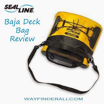
Review: SealLine Baja Deck bag for expedition sea kayaking

A deck bag is crucial for long days on the water. It provides quick and easy access to things like phones, sunscreen, hats, snacks and Gatorade pouches.
I've used a few different deck bags over the years so my requirements evolved to be very specific.

What to look for in a good deck bag for sea kayaking:

  • Made from durable waterproof material
  • Rigid structure to make it easy for me to dig around in it single handed
  • Fast and easy to open- I don't want a deck bag with a roll top closure that takes forever to open and close
  • Fast to take on and off my boat
  • Low profile to reduce wind resistance
  • Small enough to safely put in my lap under my spray-skirt in high winds without hindering my ability to wet exit
  • Splash proof
  • Dlastic d-rings to attach a strap so I can easily carry the bag on my shoulder. When I get to Ocracoke I use my deck bag like a purse- which gets me lots of strange looks.


So far my all-time favorite deck bag is the Baja Deck Bag from SealLine.


What I Love 
Size & Storage
  • Perfect Size- It is big enough to hold what I need it to, but not so big that wind resistance is a problem. It is small enough to keep in my lap under my spray skirt in extremely high winds. It has a stiff plastic insert that keeps the upper side of the bag in a curve shape which keeps the bag from collapsing and makes it easy to find your stuff. 
  • Zippered Access- There is a zipper to get into the main part of the bag- which in the above photo is covered by a rubber flap to make the zipper more water resistant. There is an outer mesh pouch that I use to keep my chapstick and other random bits in. 

Attachment Points
  • Straps to Rigging- The bag itself attaches to the deck rigging with two tough strips of rubber lined with velcro with two plastic buckles at the end. Un-clip the buckles, pull apart the velcro, and slide the straps under your deck rigging then clip to secure. I find it easy and quick to put on and take off this deck bag. I have used other bags that attach in different ways and this method is my favorite. 
  • Bungee- I use the bungee on top to hold my map and hat sometimes. The clips on the bungee are made to be a fast and easy paddle holder. I've only used them to hold my paddle a couple of times- it worked but I didn't feel like it was that secure. 
  • Carry Strap- The removable strap is the perfect length to throw over my shoulder- making it easy to carry my bag to my tent or around Ocracoke as a handbag.

So far so good. It seems like the perfect bag- and it is. Except for one major flaw. 

     The zipper sliders are metal. Why is that a problem? This is a bag for sea kayaking- in the ocean. When exposed to salt water they corrode. And no longer open or close. So you either end up with a bag that is stuck open or a bag that's stuck closed. Neither is good. 
      These are also our deck bags of choice for our sea kayaking guides at Pamlico Sea Base. We have four of them that our guides use all summer. In order to keep them working, the zippers have to be sprayed with silicone lubricant at the end of every trip. This is obviously annoying. 
      After sitting idle from August to May during our off season, they are stored in a closet in our boat shed. The boat shed is three sided, so although the deck bags don't get rained on, they aren't protected from the humidity in the air. After 9 months sitting idle, none of the zippers work. They are stuck closed. 
So until they fix this massive error, I can't say that the Baja Deck Bag is the perfect deck bag, but it's the best I've used so far. 

First Trip of the Season

    June 19th, George and I set off on the first sea kayaking trip of the 2011 summer season at Pamlico Sea base. This trip was particularly special because it was George's first sea kayaking trip! We had a small tight knit group of 6 which made it really easy for George to learn the ropes.

On the way to Cape Lookout, we stopped at Bird Island. Dustin found this really awesome knife there. If Davy Jones had a pocket knife, this is what it would look like.


Landing at Cape Lookout


George makes an awesome pirate doesn't he?


The aftermath of shoving a square box into a round hole.


On the way to Great Island Camp (AKA Fish Camp 1) Dustin caught a crab, with his bare hands, as he was paddling. Yeah, he's B.A.!


And then at Fish Camp 1, the guys caught even more!


Blue crab for dinner!


    After we reached Long Point Camp, or what we lovingly call Fish Camp 2 on Wednesday, we looked across the sound toward our Thursday destination, only to see a wall of smoke. There were several peat moss and forest fires burning in the area that had completely blocked our view of the land mass we would be heading to in the morning. All we could see was the marsh grass surrounding the ferry landing. Five miles across the sound, through the haze, was our first waypoint for Thursday morning; Cedar Island Point. Four miles beyond it, in Cedar Island Bay, was our final destination; the Cedar Island Ferry landing.

The view looking out onto the sound, only about a mile of visibility.
Typically you can see a land mass across the water.


Time to get out the map and compasses! We took a bearing from our location to our landing point using the map. It was due North. Even if we had no visibility in the morning, we wouldn't get lost.


  Every night the guys built a fire on the beach, which is trickier than building your typical campfire in the woods. It was really cool watching their fire building technique evolve over the course of the week. By Thursday night, they had it down.


   We got up at 4am Thursday morning to cross the sound. We get up this early because the wind isn't as strong this early in the morning, which makes our crossing easier. We put glowsticks on our kayaks so that any shrimping boats in the area can see us. The view of sunrise from the middle of the sound is always different and always magnificent.

The deck of my kayak ready for a pre-dawn paddle. Compass readied in case the smoke moved in as we paddled.


Sunrise that morning was pretty ominous and apocalyptic-looking. I blame the smokey conditions.


One of the scouts in his boat on our sunrise paddle.


Gimme that horizon...


Tim enjoying a well deserved ice cream at the ferry landing, waiting for the boat.


The gang on Ocracoke

Texas Iron Woman Crew 7701

I spent this week with a rockin' all girl Venture Crew from Texas; crew 7701. They did the Iron Woman, which is half a week of cycling and half a week of paddling. Thursday, we paddled to Shackleford Banks for a night on the beach.


Crew 7701 on Ocracoke


Just a mile out of Cedar Island, Pat's tire literally popped.


So I got on Wal-Mart in Morehead city on the phone(thank you Iphone and 3G!!) trying to find a new tire. He had a rental bike with odd sized tires, so he ended up riding with me some of the way back before switching out with another rider.


After a long hard day of cycling 30 miles against a 23knot headwind!


Storms on Wednesday kept us from cycling and kayaking, so we headed to the aquarium at Pine Knoll Shores. The jellyfish were mesmerizing.


The pre-kayaking pep talk. Move your body like a belly dancer!


Rebecca and Ivy at our lunch stop on Bird Island


On Brown Island,Chrissy managed to use a scallop shell to catch this tiny fiddler crab, who posed for photos.


Nicole gettin' her protein for the day.


Our kayaks lined up on the sound side of Shackleford for the night


What to do when you forget your bowl? Eat your dinner from a giant shell.


The girls took advantage of the beautiful sunset for some sweet paddling shots.
Can we say Facebook photo!


Banker Ponies! They say that long ago a Spanish galleon wrecked on the shores of Shackleford Banks, and the ponies that live there are the descendants of those marooned horses.


The girls found a sea turtle skull on the beach.


Playing in the waves


Beach art at sunrise


Suck it up and eat a steak!


Put on your big girl panties and deal with it!